- Novaya Zemlya Home
- Introduction
- Finding a route
- Disagreements among geographers
- Barentsz and Van Heemskerck
- De Veer's eye-witness account
- Het Behouden Huys
- Returning home: a hero's welcome
- Publishing matters: Cornelis Claesz
- International interest
- Archaeological remains
- The myth of Novaya Zemlya
- Quiz
- Bibliography
- Feedback form
- Copyright
![]()
Finding a route
Ever since Portuguese ships had found a sea route to Asia in the late 15th century, other nations had looked enviously upon their lucrative trade in spices such as pepper, cloves, and nutmeg. From 1590 onwards, ##the Dutch were among the nations trying to find their own passage to Asia. Before successfully completing a first voyage to the Indies around the Cape of Good Hope in 1597 however, the Dutch made three attempts to find a North-East passage to Asia.
According to geographers and other learned men in the United Provinces, a route 'om de Noord' could have several important advantages over the established route around the African continent:
-
The North-East passage was expected to be shorter than the nine-month haul around the Cape of Good Hope, as the vastness of modern-day Russia was not yet charted.
-
The low temperatures of the north were considered less daunting than the heat around the equator.
- Contact with ##enemy vessels of the Iberian kingdoms of Spain and Portugal was likely to be avoided.
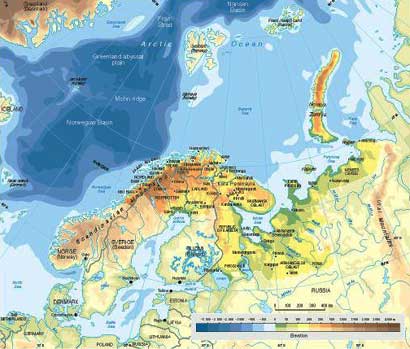
>Click here to view a larger version of the map
Regarding the route of the voyages to the North however, two schools of geographers were at odds in the late 16th century Dutch Republic. The first faction was led by the revered traveller Jan Huygen van Linschoten, the second party included the likes of Petrus Plancius, the foremost of Dutch geographers at the time, and Willem Barentsz, an experienced navigator who was to take part in all three expeditions of the mid-1590s. >Their dispute about the preferred route to Asia influenced the nature of the three expeditions to Novaya Zemlya.