- Novaya Zemlya Home
- Introduction
- Finding a route
- Disagreements among geographers
- Barentsz and Van Heemskerck
- De Veer's eye-witness account
- Het Behouden Huys
- Returning home: a hero's welcome
- Publishing matters: Cornelis Claesz
- International interest
- Archaeological remains
- The myth of Novaya Zemlya
- Quiz
- Bibliography
- Feedback form
- Copyright
![]()
Disagreements among geographers
Two conflicting views on how to reach Asia via the North were expressed in the Dutch Republic.
 #Jan Huygen van Linschoten, the first Dutchman to travel
to Asia, as a crew-member of a Portuguese campaign in the 1580s, had
received wide acclaim for his ground-breaking Itinerario, the
account of his experiences in and around the Indian city of Goa. This
book of Asian peoples and their customs remained the cornerstone of Dutch
mercantile relations to Asia until well into the 17th century. Van Linschoten
asserted that the North-East Passage to Asia could be found by navigating
through the so-called Waijgats Strait, just south of the island of Novaya
Zemlya.
#Jan Huygen van Linschoten, the first Dutchman to travel
to Asia, as a crew-member of a Portuguese campaign in the 1580s, had
received wide acclaim for his ground-breaking Itinerario, the
account of his experiences in and around the Indian city of Goa. This
book of Asian peoples and their customs remained the cornerstone of Dutch
mercantile relations to Asia until well into the 17th century. Van Linschoten
asserted that the North-East Passage to Asia could be found by navigating
through the so-called Waijgats Strait, just south of the island of Novaya
Zemlya.
The learned geographer Petrus Plancius however stated that by passing through the Waijgats Strait, one would merely reach an inland sea, currently known as the Kara Sea. He expected to find the North-East Passage by rounding Novaya Zemlya on the north, thus avoiding the Kara Sea on the island's south side.
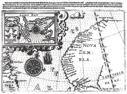
 The first Dutch expedition to Asia left from the island
of Texel in June 1594. Two ships under the command of Willem Barentsz,
following the route which Plancius had proposed, reached the northernmost
point of Novaya Zemlya, but had to return due to the impenetrability
of the ice. Two other ships, which had taken Van Linschoten's route,
discovered that the Kara Sea was not an inland sea, and could therefore
well be the gateway to Asia. All four ships returned safely to the Dutch
Republic.
The first Dutch expedition to Asia left from the island
of Texel in June 1594. Two ships under the command of Willem Barentsz,
following the route which Plancius had proposed, reached the northernmost
point of Novaya Zemlya, but had to return due to the impenetrability
of the ice. Two other ships, which had taken Van Linschoten's route,
discovered that the Kara Sea was not an inland sea, and could therefore
well be the gateway to Asia. All four ships returned safely to the Dutch
Republic.
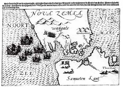
The second expedition (1595) built on the success of the discoveries of the first, following the route Van Linschoten had mapped out, through Waijgats Strait. No less than seven vessels were equipped with money and commodities for the Asian market, as the Dutch now expected to reach the Far East. To the huge disappointment of the navigators, the freezing temperatures made the Kara Sea impenetrable, unlike the previous year. The fleet was forced to return to Amsterdam.
Only Plancius and Barentsz were prepared to make one more attempt to find a North-East Passage. Since investors were predictably wary, capital was raised for only two ships. Barentsz was to be accompanied by the equally experienced Jacob van Heemskerck. In May 1596, the third expedition led by >Barentsz and Van Heemskerck left Amsterdam, aiming to round Novaya Zemlya on the north, the route which Plancius had devised in 1594.