Browse by Tags: roman
 | Up a level |
Number of items: 7.
![[img]](http://www.humbox.ac.uk//style/images/fileicons/video.png)
![[img]](http://www.humbox.ac.uk//199/2/composite.jpg)
Polynomial Texture Mapping
Shared with the University by Dr Fiona Handley
This resource consists of a short video demonstrating the use of a polynomial texture mapping rig, recording the surface features of a piece of inscribed stone, and an image which shows the how the different lighting sources and PTM software highlight tiny details in the stone surface.
Shared with the University by Dr Fiona Handley
![[img]](http://www.humbox.ac.uk//1457/1/composite.jpg)
 Preview |
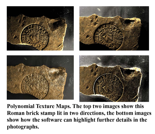
Polynomial Texture Mapping - Examples of image results
Shared with the World by Dr Fiona Handley
These four images show how the same digital data set collected through polynomial texture mapping, can be modified in the PTM software to highlight different details in the lettering and surface texture on this Roman brick stamp.
Shared with the World by Dr Fiona Handley
Preview |
Portus Exhibition 1
Shared with the World by Dr Fiona Handley
A panel from an exhibition held at Southampton Museum and the British School at Rome on the University of Southampton's Portus project.
Shared with the World by Dr Fiona Handley
Preview |
Portus Video
Shared with the World by Dr Fiona Handley
This video describes some of the archaeological fieldwork that has been taking place at the University of Southampton and University of Cambridge's excavations at Portus, the main port of ancient Rome.
Shared with the World by Dr Fiona Handley
Preview |
Roman webbing strips - an excel spreadsheet
Shared with the World by Dr Fiona Handley
This excel spreadsheet contains some data on Roman webbing strips. It records various attributes of the webbing strips and the data can be used by archaeology students to investigate e.g. correlations and frequency distributions or to generate graphs. It can be used in conjunction with the powerpoint on webbing strips
Shared with the World by Dr Fiona Handley
Preview |
Roman webbing strips - powerpoint
Shared with the World by Dr Fiona Handley
This powerpoint presentation looks at the webbing strips found at the site of Quseir al-Qadim in Egypt. They were probably used as reinforcing strips in Roman sails on boats which sailed down the East coast of Africa and across to India. It can be used in conjunction with the excel spreadsheet containing all the webbing strip data.
Shared with the World by Dr Fiona Handley
Video Exavating and processing archaeological objects at the Roman site of Portus
Shared with the University by Dr Fiona Handley
A short video covering the excavation of objects, showing bags of environmental samples, and the sorting and processing of finds from the Roman site of Portus in Italy.
Shared with the University by Dr Fiona Handley


